Archive for the ‘holy well’ Tag
Never mind that the world is going to hell in a motorised golf-cart, never mind that the next volcano will trigger the collapse of tourism and take our livelihood down with it – this May day was insanely munificent : it kept delivering surprises and delights that went way past what I asked for.
This is the day that was in it : hot sun and breezes, grassy gullies and massive rock-shelters, micro-vineyards interplanted with young olives, ancient cherry-trees and antique wells, wierd rock-formations and a rare stone-alignment . . . and a long-lost dolmen.

The walk up the combe was lush with grasses, wild asparagus and fennel – but the path led upward onto the hot stoney causse.

But up among the hot vines was a cool slot : limpid water gulped down, flavored with wild aniseed.

It’s a complex photo, but a simple scene : one ancient ‘guine’ or sour cherry; one stone shed with an old Peugeot, and one extraordinary stone chamber above. On the bed of the truck was a note : ‘VENEZ BOIRE une verre à la maison au-dessus. Pascal.’ An invitation to a friend, or to the world?

Stumbling around on the top of this little ‘causse’, I found this row of stones. Three are visible and another 6 disappear into the scrub : all in a clear 15 metre line running south-east: towards the winter solstice. At first I thought this was ‘the dolmen’, and was mightily disappointed – it looked all wrong. [More on the cromlech/stone alignment of Saussenac in the next post & Page].
But I have done my homework : I have identified other likely ‘white blobs’ on Google Earth, and I have Paul Ambert’s generalised description from the ’70’s and so it’s on up into the sea of prickly ilex. And after an hour of thorns and trees and scrub, a stoney ‘island’ appears, with that heart-jolting, breath-seizing glimpse of a white slab jutting above the garrigue : it’s there! It does exist!

It’s huge and it’s magnificent – and it’s a complete wreck.
The photos that follow, on the Combe Lignières Dolmen Page, will show what a mess time and peasants and archaeologists have made of the place. This is the Last Stone Standing. As usual, it’s the primary, eastern orthostat – almost always the deepest set and the biggest. Yet this recurrence is never mentioned by any of the experts who have visited all these dolmens of ours, over the past century. Do they not see these as buildings, as architecture? Do they only see them as ‘boxes’ that hold the objects they are so desirous of?
The expertise of archaeologists is not in doubt here – but the narrowness of focus has I fear, led to a failure of imagination. The subject of Ruins is going to be a recurrent theme in subsequent posts.
The day didn’t end there :

This old fellow was in clover – he thinks Combe Lignières is heaven.
We live under the slumbering bulk of Alaric, and forget how large it looms to others.
When architecture and landscape mean so much to ordinary people, I wonder at their exclusion by archaeologists : Ambert’s insistence that the Combe Lignière dolmen is oriented to the north – when this view is so present to the south.

The dolmen hunter’s reward :

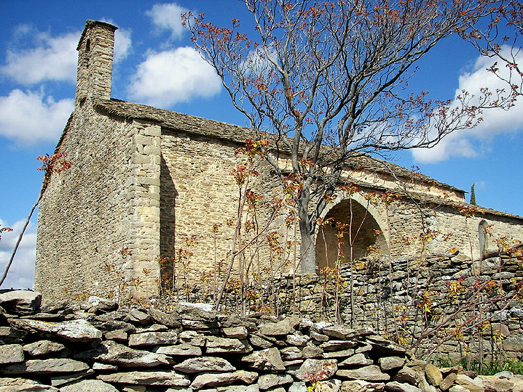
In the XIII century, (some texts say the XII century) La Chapelle de Notre-Dame de Centeilles was built close to the site of a romanesque chapel, or of a Roman villa. Throughout the Middle Ages Centeilles was the centre of a thriving community on the trail between plain and mountain and was the focus of an important fair and market on 25th and 26th March. It was also a centre of pilgrimage for Ascension Day, with its Procession of the Rogations, and Assumption Day.

The first fresco to face the weary pilgrim was that of St. Christopher, patron saint of travellers.
La Révolution put an end to this tradition – the human population deserted it, and it was used as a barn. For the next one hundred years it was occupied by sheep. It was sold in 1960, for 500 francs. to the Diosese of Narbonne who later handed it over to Les Amis de Centailles, an association that undertook its repair and upkeep.

The early christian church had not chosen this place at random – it was a site of sacred significance since the earliest times. For wherever Our Lady has been installed and adored it is certain that she replaced a pre-christian animist or fertility cult – usually of Cybele, or Potnia Theron, the Queen of the Animals – one of the myriad names of the Mother Goddess.
For more photos and info- see the Chapelle de Centeilles Page
Quid is France’s Encyclopedia Britannica, on paper since 1967 and online since 1997. IGN is the Institute Géographique National – it began as an army mapping service in 1887 and went public in 1967. They are invaluable tools in researching old stones but they are not without weaknesses. This is what I found for Siran, a village nearby in the Minervois:
Cachette de fondeur de l’âge du Bronze à Centeilles. [Traces of Bronze Age smelting]
29 dolmens* et tumulus.
Habitat préhistorique à Centeilles, Ausine, Belvédère.
Champ des Morts.
Nécropole 1er âge du Fer à La Prade.
14 villas romaines, principalement : Najac, Saint-Michel de Montflaunez.
Oppidum du pic St-Martin occupé de l’âge du Fer au 6ème apr.J.-C.
Mosaïque gallo-romaine* à la chapelle de Centeilles.
Tombes wisigothiques à La Rouviole, Le Champ des Morts, Centeilles, Saint-Martin, Saint-Pierre des Troupeaux, Saint-Gontran.
And this is what the new IGN map says is there:

Centeilles seemed central to this rich and diverse little corner, and was one of the few from the list to be marked on the map, as was the Gallo-Roman fort [camp or oppidum] closeby. That confident red star looked a certain bet, so I set off this saturday to see what I could find – knowing that information on Quid could well be long out-of-date and that I could be beating around the bush all afternoon for nothing. But not suspecting that the map could get it so wrong.

The 13th.C. Chapelle de Notre-Dame-de-Centeilles was certainly there with its stone roof and holy well – as was a host of other fascinating structures and features [see following Posts & Pages] – and so were the remains of a massive emplacement deep in the wood where the map shows the red star. It wasn’t until I got home and compared this new map with the 1967 version that doubt set in about The Thing in the Wood. I now needed to persuade Jessi and Mary to come out on another hunt this sunday.
The story of this weekend’s two visits to Centeilles is complicated, so the photos about it all are over on the Pages section. Starting with the Not the Gallo-Roman Camp Page. And as fast as I can post them, the following will appear :-
The real Ancien Camp Gallo-Romain on the Pic St-Martin Hillfort Page.
The dolmen of Centeilles – or les Pierres Plantées, take your pick – on the Centeilles Dolmen Page.
The dolmen du Mourel des Fadas – on the Dolmen des Fadas Page.
The Chapelle de Notre-Dame de Centeilles – the extraordinary frescoes, its history, holy well and capitelles – on the Chapelle de Centeilles Page.
And the second earlier church at Centeilles [in many ways even more extraordinary] – on the Chapelle Ruinée Page. There was a third even earlier church here at one time – but it’s been lost . . .
And then there’s those Roman villas, and the visigoth necropoli, and the neolithic habitat here too, somewhere – but I need another visit or ten, for them.