
We’re losing dolmens. Every year around here, dolmens go missing. It’s no joke: one day there are two on a map plus a menhir – and then on the new map there are none – just the menhir.

Last week we found one of them – but it too is disappearing fast. Few people go there, no signs point the way, and the paths are no longer trodden by human foot. The tracks are beaten by wild boars and are closing over with dwarf box and juniper.
A ten minute drive on a single-track metalled road up out of Félines-Minervois, a non-descript little village a half-hour ENE of Carcassonne, brings us to a belvedere parking area. There’s a sign up left for Bel Soleil, a group of three small houses and for Ventajou a ruined fort. It’s a 20 minute walk up the farm track – and another half-hour up the hill-path to get to the menhir, a modest affair 5 ft.tall by 3ft. wide, facing south-east.


Then we had to figure out which boar-track led uphill to where we guessed the dolmen might be (going by the older map). What little track there was petered out after a couple of minutes – but there was a glimpse of stone in under some evergreen oak, and we scratched our way up towards that. The video shows what a mess of rock we found. I was not convinced – but not disheartened either : where there’s the right rocks – there’s hope.
Letting my feet take the line of least resistance – no more than a faint groove in the hill, almost obscured by knee-high box shrub – I went on up a bit and caught sight of an angular arrangement, a vestige of architecture amid the jungly incoherence. Someone had cleared a few shrubs – maybe a year or so ago – but it was being invaded afresh, and would be lost again in a while.
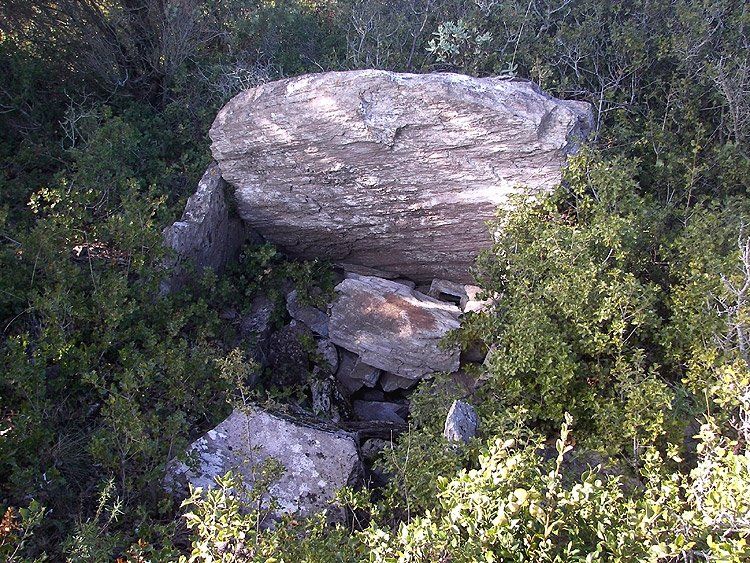
The capstone was just under a metre square, while the orthostats were 80 cm wide and 50 cm high left side, 70 cm wide and 30 cm high on the right side. The length was hard to judge with all the rubble, but no more than a metre : un dolmen simple.

Somewhere higher up and clear of the encroaching garrigue, on the barer limestone hill-brow, lay the second dolmen : it would have to wait for another day.
Out of breath – or simply inarticulate? Here’s the little lost dolmen:
I’m beginning now to get a feel for these places. There’s a logic in the dolmen landscape : limestone uplands, with a southern aspect, one or more caves or avens in the vicinity, a river, and possibly a commanding vantage point that is defensible – in this instance the oppidum/ruined fort of Ventajou. The Bel Soleil site has all these requirements.
The village of Félines boasts these following features close-by (though half of them don’t appear on either of my maps . . .)
Aven d’Argentières.
Grottes préhistoriques de l’Abeuradou, La Bouriette, Le col de Fontanelles, Argentières, Catsalaric.
27 dolmens à Argentières, La Matte, Coste Grande, Les Bessous, Rec de las Balmos, Belsoleil, Ventajou, Polignan, Babio ; La Planette, Combe Lignières, Catsalaric, Chaffret.
Tumulus à La Matte, La Planette.
Menhir à Rec de las Balmos.
Station néolithique de Dorio.
Oppidum pré-romain à Sarroz.
Villas romaines à St-Peyre, Balmos, Ventajou.
Tombes à lauzes à St-Nazaire, l’Abeuradou, Le Viala, Le Village.
Nécropole wisigothique à St-Peyre.
This list doesn’t include the sizeable though derelict passage-grave of Jappeloup, in deep forest due south of the Bel Soleil site, and marked on both maps.
Nor does it mention the half-dozen ‘ancient mines’ dotted all over the vicinity. One of these produced maganese – while a few kilometers west is the now-closed mine at Salsignes – until recently Europe’s largest gold mine. The importance of this short stretch of hillside in the Minervois, from the earliest days of human habitation, is undeniable.
All-in-all this little area could take me a year of weekends to explore – and even then I fear that many of the sites mentioned would be untraceable, unless I can find a old local historian (and hillwalker) who can help me find the precise locations. A similar situation holds true just to the west, around Caunes-Minervois, and to the east of here around Minerve – a wealth of grottes and tinals (caves/rock shelters), avens (potholes) bories (circular stone huts) – and dolmens.


Very interesting! thanks for the great photos. We tried to find the dolmen near St Nazaire in northern Gard, with no luck. We were led to the forest of Pigeaud but found only a maze of small trails through garrigue. Were we close? Where does one find a map for these things?
Thanks, Diane. Gard is a quite a way off my patch, so I can’t help there. But your experience is a common one – only the biggest and best-preserved megaliths get marked on maps, or signposts. The rest are known to local historians, and to the hunters who beat about the hills regularly. Someone at ‘La Mairie’ will put you in contact with these people. Happy hunting.
I think that I have found all Bel Soleil megaliths. it was hard but in an afternoon, 12 dolmens and 1 menhir were photographied.
I have also made a map of these “plateau” and I hope that it is the most correct as possible.
Bravo! Et dans une chaleur extreme! Felicitations. This was evidently a very important place, and so near Bois Bas. Well done: a major achievement on very difficult terrain. I look forward to seeing your next publication. Richard
nice pictures, what camera do you use ? do you measure the orientation of the chamber ? in principle do you find a standing stone near the dolmen ?
nice website!
Thanks Jean. It’s a mid-range Kodak, from a few year’s back – really nothing special. My Mary has it in Ireland at the moment and I’ll tell you the model later. It may be discontinued – but at the time it got good reviews for its 12 x zoom, anti-shake, and good colour.
Yes usually I bring a compass with me, and note the orientation. I must have forgotten it that time!
I’ve only been hunting dolmens a short time – but it seems that standing stones are quite rare down here (though some very big ones are here, too). They do not seem to be connected. It is possible that being phallic and pagan, they were broken or removed or knocked down by christians. Or farmers! I went looking for one yesterday, having noticed it marked on a local map – but there was nothing to be found. This happens quite frequently – a lot of walking about in hot sun, looking foolish, finding nothing . . .
Are you in Belgium? Have you found many there?
Keep in touch – and thanks again for your kind words.